Why cyclones lose power over land, but the rain keeps coming
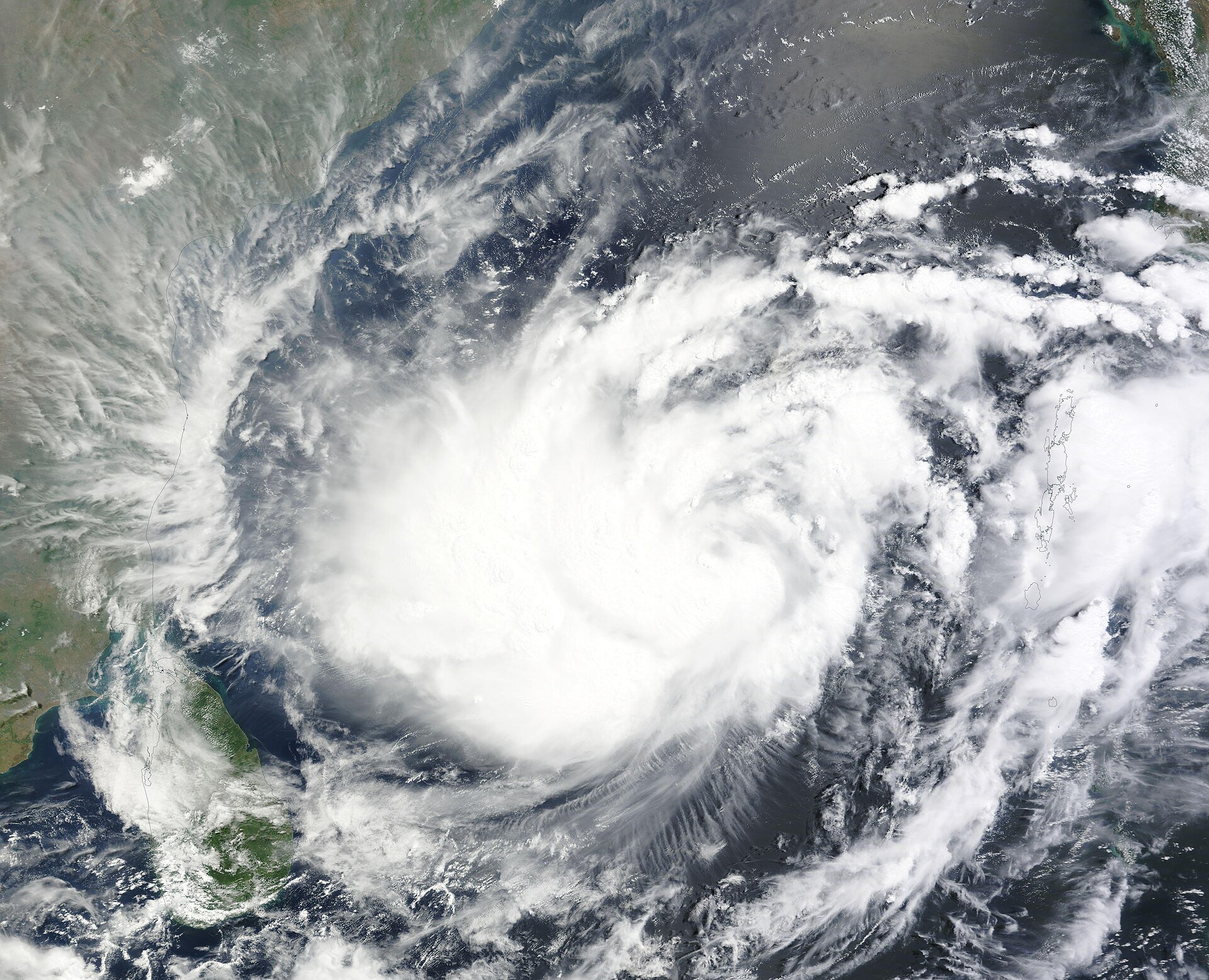
On Wednesday, Cyclone Akvan was a severe cyclonic storm in the Bay of Bengal, with winds of 90 to 100 km/h gusting to 110 km/h. By Friday evening it had become a depression over south Odisha, about 70 km from Angul, and was expected to fade into a low-pressure area within hours. Yet Ganjam district was soaked, with Patrapur recording 209 mm of rain in a day.
So how does a monster storm lose its punch so fast, and why does the rain carry on? The answer is all about fuel.
A cyclone is a stove that runs on warm sea
Think of a cyclone as a giant gas stove. Its fuel is warm, moist air rising off the ocean. The India Meteorological Department (IMD) says cyclones need sea water of at least 26.5°C, warm to a depth of around 50 metres, along with moist air higher up and light winds in the upper atmosphere.
As that moist air rises and cools, the water vapour turns into cloud and rain, and releases heat. That heat drives more rising air, which pulls in more moist air from the sea surface. As long as the stove is connected to the cylinder, the flame keeps going.
What happens at landfall
Landfall is when the centre of the storm crosses the coast. Akvan crossed near Gopalpur in Odisha between 7:30 and 8:30 am on Friday, 20 November, as a cyclonic storm with winds of 70 to 80 km/h gusting to 90 km/h.
Over land, the cylinder is switched off. US weather scientists at NOAA explain that a storm over land lacks the moisture and heat sources that the ocean provided. With less fuel, fewer thunderstorms form near the centre, and the storm quickly winds down. That is why IMD expected Akvan to drop to a deep depression within about three hours of landfall, and then to a depression.
Friction plays a part too. Trees, hills and buildings slow the steady winds near the ground. But NOAA notes a twist: that rough surface also churns the air, which can bring short, fast gusts down to the ground. So a weakening storm can still bring down trees, as happened in nine Odisha districts.
Akvan started weakening before it even arrived
Land is not the only thing that starves a cyclone. Cooler water does the same job. IMD Director General Mrutyunjay Mohapatra said Akvan weakened from a severe cyclonic storm to a cyclonic storm before reaching the coast because of relatively cold sea surface temperatures near the shore.
Canada's weather service lists other storm-killers as well: strong winds that change with height, called wind shear, which tear the storm's structure apart, and cool, dry air being sucked in. Akvan's track also shifted. It was first expected to hit Andhra Pradesh and finally came ashore in Odisha.
Why the danger does not end with the wind
A weakening cyclone is still a huge bag of water vapour drifting over land. IMD says heavy rain usually starts 9 to 12 hours before landfall, and a cyclonic storm can bring around 50 cm of rain in a day, enough to cause flash floods. After Akvan crossed, IMD put 14 Odisha districts on orange alert for very heavy rain, and Odisha's disaster management minister said the next 12 hours remained critical as the cyclone's remnants kept bringing rain.
Waterlogging hit Bhubaneswar and Cuttack, the Rushikulya river rose, and heavy rain was forecast for parts of south Bengal into Saturday. The state ruled out an immediate flood threat, with officials saying rivers were unlikely to cross the danger mark.
At the coast, the biggest killer is usually not wind or rain but storm surge, an abnormal rise in sea level as the cyclone comes ashore. IMD says it can flood low-lying areas and leave the soil salty, and it is worse if landfall coincides with high tide. For Akvan, IMD had warned of a surge of 0.5 to 1 metre along parts of the Andhra Pradesh and Odisha coasts.
Not every storm fades fast
Some storms hold on. IMD points out that the 1999 Odisha super cyclone stayed at cyclonic storm strength for about 24 hours after landfall.
There is also a warning from research. A 2020 study in Nature, by scientists at the Okinawa Institute of Science and Technology, found that North Atlantic hurricanes now weaken almost twice as slowly in their first day over land as they did 50 years ago. The reason: storms that form over warmer seas carry more stored moisture. The team said it still needs to check whether the same pattern holds in other ocean basins, including ours.
So what?
When you hear that a cyclone has "weakened into a depression", it means the winds have dropped, not that the danger has gone. Keep watching IMD's rain warnings for the next day or two, stay away from swollen rivers and low-lying roads, and follow local evacuation advice. In Odisha, more than 4.4 lakh people were moved to safety ahead of Akvan.
Did you know? According to Odisha's minister, 1,452 babies were born after their mothers were moved to safer places ahead of the storm.
- Akvan a severe cyclonic storm on 18 Nov, winds 90-100 km/h gusting 110; storm surge 0.5-1.0 m forecast for parts of coastal Andhra Pradesh and Odisha: IMD National Bulletin No. 23, 18 Nov 2026
- Landfall near Gopalpur 7:30-8:30 am on 20 Nov as cyclonic storm, 70-80 km/h gusting 90; weakened before landfall due to relatively cold SST near shore (Mohapatra); depression ~70 km SSW of Angul; Patrapur 209 mm; orange alert 14 districts; remnants bring rain, next 12 hours critical; no immediate flood threat; Rushikulya rose; waterlogging in Bhubaneswar and Cuttack; tree-felling in nine districts; track shifted from Andhra Pradesh; over 4.40 lakh evacuated; 1,452 babies delivered: ThePrint (PTI), 20 Nov 2026
- IMD forecast weakening to deep depression within three hours, then depression; heavy rain in south Bengal until 21 Nov: Outlook, 20 Nov 2026
- Formation needs SST of at least 26.5°C to about 50 m; landfall definition; over land loses moisture and heat; friction lowers sustained winds but can raise gusts; 1999 Odisha super cyclone kept CS strength about 24 h after landfall; storm surge greatest killer, worse at high tide; heavy rain 9-12 h before landfall, around 50 cm a day: IMD RSMC New Delhi, Cyclone FAQ
- Over land a storm lacks the moisture and heat sources the ocean provided; friction reduces sustained winds but increases gusts: NOAA Hurricane Research Division, FAQ
- Cyclones also die over cold water, under strong wind shear and when cool dry air is drawn in: Environment and Climate Change Canada
- 2020 Nature study: North Atlantic hurricanes decay almost twice as slowly in first day after landfall than 50 years ago, due to stored moisture from warmer seas; other regions still to be studied: Okinawa Institute of Science and Technology, 11 Nov 2020
Spotted a mistake or have an idea for a read? Write to [email protected].
